Situated in the heart of Germany, Wetterau offers a distinct meteorological vantage point. Its geographical position and topographical nature render it a pivotal observation post for climate shifts. This late summer has unveiled several noteworthy weather phenomena that hold significance from both meteorological and societal viewpoints. The summer was extended and warm, shattering many global records. Though not as hot as previous years, it maintained warmth for a considerably prolonged duration.
Wetterau's Multifaceted Late Summer
The July Heatwave
While July had a gentle commencement, it quickly escalated, marking an impressive peak temperature of 36.3°C on July 9th at 16:45. This record wasn't just for the month but stood as the zenith for the entire summer. However, this heat benchmark was soon supplanted by cooler days and rainy intervals that dominated the latter part of July, ushering in temperatures ranging between 14 and 20°C.
July archive of my weather station
August – A Month of Contrasts
The drought-inducing dryness of May and June was partially offset by August's rainfall. But by mid-August, we noted a renewed surge in temperatures, with readings frequently touching the 30°C mark, partnered with nights hovering around 18°C. These climatic conditions cultivated atmospheric tensions, culminating in multiple thunderstorm fronts.
August archive of my weather station
Thunderstorm Activities and Their Distinctiveness
Traditionally, Wetterau was recognized for its relatively mild thunderstorms, as many storm fronts here were less pronounced or bypassed entirely. However, this year deviated from the norm, with some storm cells directly sweeping across — fortunately without major incidents as witnessed elsewhere.
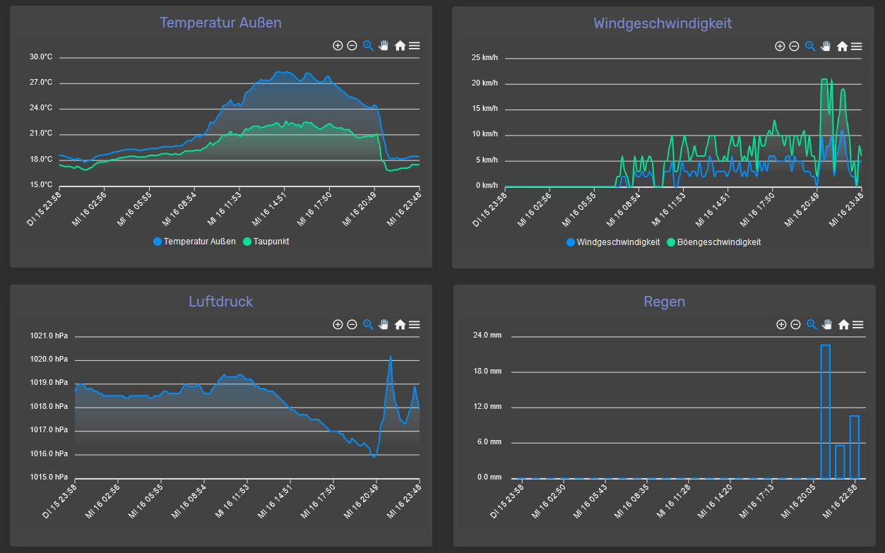
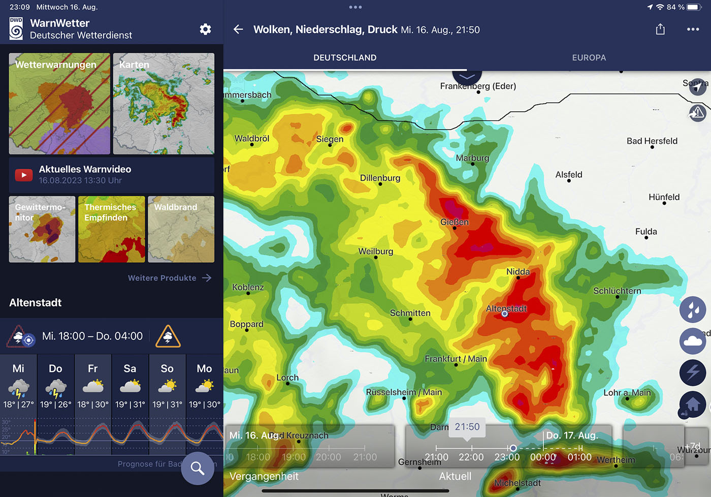
Of particular note was the storm on August 16th. Within a few hours, it deposited 39 liters of rain per square meter, plummeting the temperature from 27°C to 18°C. Screenshots from that day depict a remarkably high lightning frequency, testament to the atmospheric energy discharged. Luckily, the region faced no significant disruptions, barring some fallen trees in the forest. Meanwhile, Frankfurt's South Station was submerged.
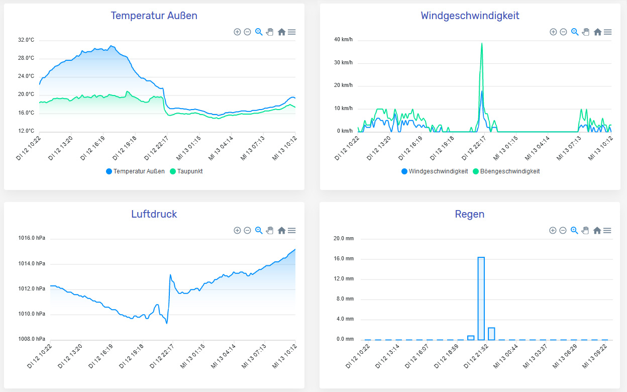
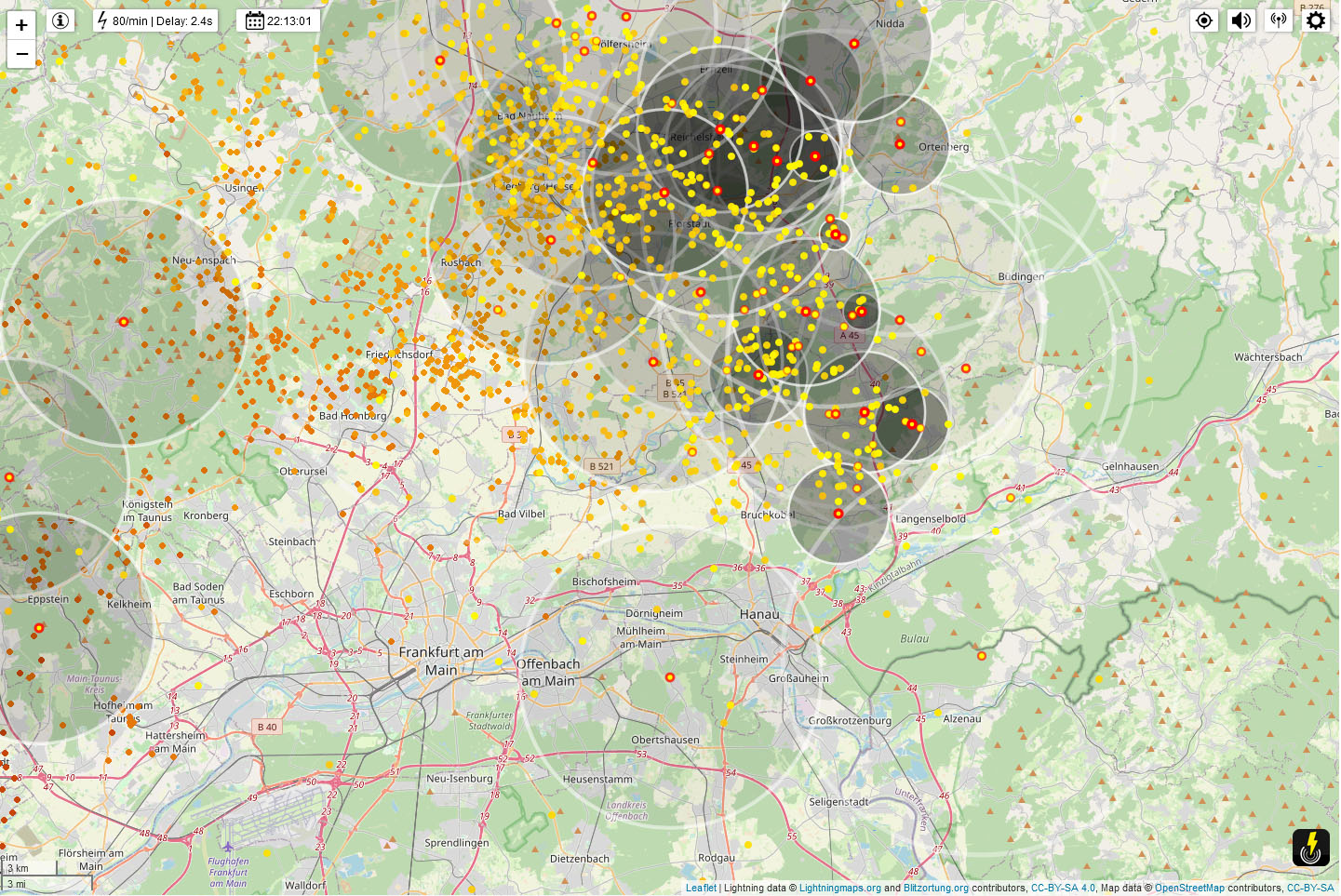
Another prominent event was the thunderstorm on September 12th. On this day, we recorded temperatures above 30°C, interrupted by a fierce storm with nearly 20 liters of rainfall per square meter and intense wind gusts. This temperature plunge from 28°C to 17°C was accompanied by a staggering lightning frequency — with about 80 flashes per minute, as documented by Lightningmaps.org for Wetterau and the northern Rhein-Main region.
Especially noteworthy were these sudden intense winds and swirls, which historically were rare for the region during storms but were conspicuously present in these two potent tempests.
A Balmy September
Aside from the heavy rain (22 liters per square meter) on September 1st and the aforementioned storm on September 12th, the remainder of the month was predominantly dry and tranquil. Peak temperatures consistently exceeded 18°C, with most days between 25-30°C.
While my younger years sometimes saw September as an early autumn, it can now be more aptly classified as a late-summer month — a climate much appreciated by my tomatoes, chilies, and citrus trees.
September archive of my weather station
October – A Gentle Conclusion?
October surprised with continued mild days and temperatures around 20°C. This warmth persisted until mid-month, with nights predominantly above 10°C. However, forecasts indicate a possible shift with significantly cooler temperatures from the north, hinting at an impending onset of frost, more fitting for mid-October. We await with anticipation — a snowy, cold winter seems overdue.
A small update 3 days later: Now the days are as cold as the nights have been a few days earlier, and the trend continues. Tonight we had -1,3°C for the first time this season.
The Role of Modern Technology
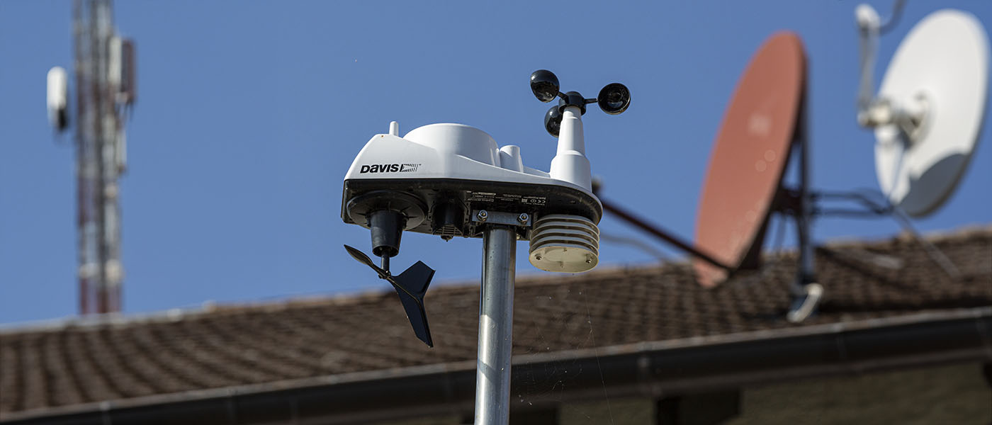
Over recent decades, technological advancements have revolutionized the way we monitor and document weather. My personal garden weather station epitomizes this. Armed with reliable, professional equipment, it has consistently captured precise weather data for over a decade. This not only grants a profound comprehension of short-term weather phenomena but also facilitates the observation of more extended climatic patterns and trends.
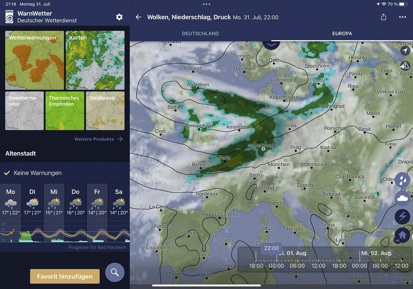
Modern weather applications such as WarnWetter and tools like Lightning Maps and Windy perfectly complement this data. While the home-based weather station provides real-time, specific local data, these apps and platforms offer a broader context by spotlighting regional and broader weather events. The fusion of these technologies facilitates comprehensive documentation and analysis, which would have been unimaginable a few decades ago. It's captivating how the amalgamation of local measurements and global data presents us with a detailed portrayal of our evolving environment.
Conclusion
The meteorological peculiarities of Wetterau's late summer not only intrigue climate researchers. They serve as stark reminders of the tangible climate change manifesting even in our latitudes. This year's weather data and observations may well be the harbinger of future trends. It begets the question — how should society respond to these shifts and what proactive steps should we undertake?
How did you perceive this year's late summer in Wetterau or your region? Do your observations mirror or diverge from mine? Share your thoughts and experiences in the comments below.
This post was created with the support of artificial intelligence (GPT-4). Curious how AI can create such texts from its own ideas? Learn more about it on the website of the Neoground GmbH - Your partner for AI-Consulting, web development, and digital strategies.


Noch keine Kommentare
Kommentar hinzufügen